Παράξενοι Χάρτες
Να ενα θεματακι που δεν εχουμε ανοιξει ακομη...Πολλοι ειναι οι παραξενοι χαρτες που σπαζοκεφαλιαζουν τους γεωγραφους και χαρτογραφους.Αγνωστα νησια και γεωγραφικοι σχηματισμοι που υπο κανονικες συνθηκες δε θα επρεπε να βρισκονται εκει!Ποιες λογικες εξηγησεις θα μπορουσαν να δωθουν;Εχετε υπ'οψιν σας και αλλους τετοιους χαρτες;
Για αρχη παραθετω τον γνωστοτερο ολων, αυτον του Τουρκου ναυαρχου Πιρι Ρεϊς(1513) που εχει εξαψει τη φαντασια των ερευνητων παρουσιαζοντας τις ακτες της Ανταρκτικης!Ο Πιρι Ρεϊς παραδεχτηκε οτι χρησιμοποιησε σαν πηγες του χαρτες του Κολομβου αλλα και αλλους παλαιοτερους.Ποσο παλαιοτερους ομως ωστε να παρουσιαζονται οι ακτες της λευκης (πλεον) ηπειρου,οπως ακριβως πριν 16.000 χρονια απο σημερα;
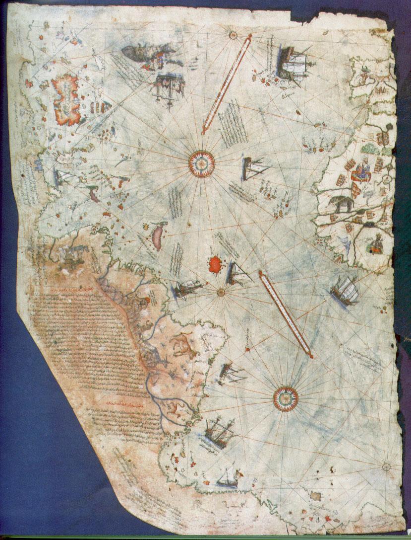
Για αρχη παραθετω τον γνωστοτερο ολων, αυτον του Τουρκου ναυαρχου Πιρι Ρεϊς(1513) που εχει εξαψει τη φαντασια των ερευνητων παρουσιαζοντας τις ακτες της Ανταρκτικης!Ο Πιρι Ρεϊς παραδεχτηκε οτι χρησιμοποιησε σαν πηγες του χαρτες του Κολομβου αλλα και αλλους παλαιοτερους.Ποσο παλαιοτερους ομως ωστε να παρουσιαζονται οι ακτες της λευκης (πλεον) ηπειρου,οπως ακριβως πριν 16.000 χρονια απο σημερα;
Προφανός χάρτης ηλικίας 16.000 ετών
Αγαπητέ echosan από πού εξάγεται το συμπέρασμα για την ηλικία;
Mαλλον επειδη η ακτογραμμες της νοτιας αμερικης με την ανταρκτικη εφαπτονται τελειως και για αλλες λεπτομερειες..
Το ότι κάτι υπάρχει σε χάρτη δεν σημαίνει ότι υπήρξε, αλλά και ότι κάτι δεν υπάρχει σε χάρτι δεν σημαίνει ότι δεν υπήρξε. Ο χάρτης δεν είναι τίποτα άλλο απο μια περιγραφή ενός τόπου χωρίς όμως να είναι η απόδειξη της ύπαρξης του άλλωστε ο Πλάτων κάνειι μια λεπτομερή περιγραφή για την Ατλαντίδα η οποία δεν υπάρχει πλέον. Τα λόγια του Πλάτωνα είναι ένας χάρτης και η ύπαρξη αυτού του χάρτη δεν σημαίνει ότι υπήρξε η Ατλαντίδα, αλλά αν ο Πλάτων δεν είχε μιλήσει ποτέ, δεν σημαίνει ότι κάποτε δεν υπήρξε...
Ντα!
Ντα!
Πως από το ότι ο χάρτης φαίνεται να δείχνει τις ακτογραμμές τις Νοτίου Αμερικής και της Ανταρκτικής να εφάπτονται συμπεραίνεται κάποια ηλικία και ποιες είναι οι άλλες λεπτομέρειες;
Μετά από πολύ καιρό, να προτείνω τα εξής:
1.Ο Πίρι Ρέϊς είχε “άλλες” πηγές (όπως και αναφέρει) και δημιούργησε αυτό το χάρτη.
2.Μπορεί να θεωρούσε σαν λογική συνέχεια της Ν.Α. την Ανταρκτική και να τις ένωσε απλά, μου φαίνεται όμως λίγο ακραίο, για ναύαρχο και θαλασσοπόρο εκείνης της εποχής.
3.Εκείνη την περίοδο να ήταν πάγοι από τη Ν.Α. μέχρι την Ανταρκτική και να δημιούργησε το χάρτη όπως ήταν η έκταση που κάλυπταν οι πάγοι. Και αυτή η εκδοχή όμως είναι ακραία, γιατί αν θυμάμαι καλά πολλοί θαλασσοπόροι (δεν θυμάμαι για τον Μαγγελάνο) είχαν περάσει από τη Γη του Πυρός.
1.Ο Πίρι Ρέϊς είχε “άλλες” πηγές (όπως και αναφέρει) και δημιούργησε αυτό το χάρτη.
2.Μπορεί να θεωρούσε σαν λογική συνέχεια της Ν.Α. την Ανταρκτική και να τις ένωσε απλά, μου φαίνεται όμως λίγο ακραίο, για ναύαρχο και θαλασσοπόρο εκείνης της εποχής.
3.Εκείνη την περίοδο να ήταν πάγοι από τη Ν.Α. μέχρι την Ανταρκτική και να δημιούργησε το χάρτη όπως ήταν η έκταση που κάλυπταν οι πάγοι. Και αυτή η εκδοχή όμως είναι ακραία, γιατί αν θυμάμαι καλά πολλοί θαλασσοπόροι (δεν θυμάμαι για τον Μαγγελάνο) είχαν περάσει από τη Γη του Πυρός.
Παιδιά να ρωτήσω κάτι. Αφού όπως βλέπω ο χάρτης είναι λίγο χάλια σε σχέση με τους μοντέρνους και έχει πολλά λάθη. Γιατί λέμε ότι αυτό το βρήκε σωστά ο ναύαρχος και τα άλλα που τα έχει παραμορφωμένα δεν μας ενδιαφέρουν. Πώς ξέρουμε ότι δεν έκανε λάθος και εκεί πέρα και τράβηξε την γραμμή παραπάνω από ότι έπρεπε. Γιατί δηλαδή να μην είναι η Αργεντινή αυτό το πράγμα και να είναι η Ανταρκτική? Μου φαίνεται λίγο μάπα.
http://www.reuters.com/resources/r/...t=2&i=501209&w=
Άγγλοι, Γάλλοι, Πορτογάλλοι, Γερμανοί και παπαγάλοι, ποιός ανακάλυψε την Αυστραλία?
Το πρακτορείο ρόιτερς (γιατί το λένε πρακτορείο ποτέ δεν το κατάλαβα, παίζεις και προπό εκεί? ) λέει ότι βρήκανε ένα πορτογαλλέζικο χάρτη που είναι 250 χρόνια πιο παλιός από τον κυρ.Κούκ που μαθαίνουμε ότι ανακάλυψε τους Αυστραλιανούς
http://www.reuters.com/article/topN...YD3449720070321
http://www.reuters.com/resources/r/...t=2&i=501209&w=
Άγγλοι, Γάλλοι, Πορτογάλλοι, Γερμανοί και παπαγάλοι, ποιός ανακάλυψε την Αυστραλία?
Το πρακτορείο ρόιτερς (γιατί το λένε πρακτορείο ποτέ δεν το κατάλαβα, παίζεις και προπό εκεί?
) λέει ότι βρήκανε ένα πορτογαλλέζικο χάρτη που είναι 250 χρόνια πιο παλιός από τον κυρ.Κούκ που μαθαίνουμε ότι ανακάλυψε τους Αυστραλιανούςhttp://www.reuters.com/article/topN...YD3449720070321
Για την ακρίβεια του χάρτη έχουν προταθεί αρκετές θεωρίες, αρκετές από τις οποίες περνούν στο χώρο της επιστημονικής φαντασίας, καθώς προϋποθέτουν εναέρια παρατήρηση.
Η ακρίβεια, ωστόσο, του χάρτη προϋποθέτει γνώσεις σφαιρικής τριγωνομετρίας και γνώση της μεθόδου της αζιμουθιακής προβολής των ίσων αποστάσεων.
Η παραδοχή του τούρκου ναυάρχου ότι χρησιμοποίησε παλαιότερους χάρτες, οδηγεί στην υπόθεση ότι υπήρχε η δυνατότητα τέτοιου είδους μετρήσεων σε παλαιότερες περιόδους της ιστορίας.
Η ακρίβεια, ωστόσο, του χάρτη προϋποθέτει γνώσεις σφαιρικής τριγωνομετρίας και γνώση της μεθόδου της αζιμουθιακής προβολής των ίσων αποστάσεων.
Η παραδοχή του τούρκου ναυάρχου ότι χρησιμοποίησε παλαιότερους χάρτες, οδηγεί στην υπόθεση ότι υπήρχε η δυνατότητα τέτοιου είδους μετρήσεων σε παλαιότερες περιόδους της ιστορίας.

world map by Moroccan cartographer al-Idrisi for king Roger of Sicily

Possibly what the lost first map of the world by Anaximander looked like, based on an image found in An Introduction to Early Greek Philosophy by John Mansley Robinson, Houghton and Mifflin, 1968

Hecataeus of Miletus (c.550-c.490): Greek geographer and researcher, designer of a world map and author of a book on chronology.
...γιατί η λεπτομέρεια κάνει τη διαφορά

Δ.

Beatus (c. 730 - 798) was a Spanish monk and theologian. He corresponded with Alcuin, and took part in the Adoptionist controversy, criticizing the views of Felix of Urgel and Elipandus of Toledo. He is best remembered today as the author of his Commentary on the Apocalypse, published in 776. The Commentary also contained one of the oldest Christian world maps. Although the original manuscript and map has not survived, copies of the map survives in several of the extant manuscripts.

Andrea Bianco's atlas of 1436 comprises ten leaves of vellum, measuring 29 X 38 cm., in an 18th century binding. The first leave contains a description of the Rule of Marteloio for resolving the course, with the "circle and square", two tables and two other diagrams. The next eight leaves contain various navigation charts. The ninth leave contains a circular world map measuring 25 cm in circumference. And the final leave contains the Ptolemaic world map on Ptolemy's first projection, with graduation. Some believe Bianco's maps were the first to correctly portray the coast of Florida, as a macro-peninsula is attached to a large island labeled Antillia. Bianco also collaborated with Fra Mauro on the Fra Mauro world map of 1459.

The Cantino planisphere is the earliest surviving map showing Portuguese discoveries in the east and west. It is named after Alberto Cantino, an agent for the Duke of Ferrara, who successfully smuggled it from Portugal to Italy in 1502. The map is particularly notable for portraying a fragmentary record of the Brazilian coast, accidently discovered in 1500 by the Portuguese explorer Pedro Álvares Cabral (he correctly conjectured that he had landed on part of a continent previously unknown to Europeans)
Δ.

Carlos Sanz points out, if the east coast of the North America is compared with modern-day maps, we will be struck by its immediately noticeable similarity with the coastline stretching from Florida to the Delaware or Hudson River. "This would appear to be impossible", he adds, "when we consider the general belief that the Europeans neither saw nor set foot on the beaches in the southern states of the present-day U.S.A.

A 15th-century world map might be the key to a mystery that has confounded historians for almost five centuries: the identity of legendary isles near the North Pole.
The map, by Venetian cartographer Albertin DeVirga (ca. 1414), surfaced at a Croatian antique store in 1911. This map has recently attracted the attention of historians due to claims that it shows parts of North and South America long before voyages by Columbus, Vespucci, Cabot and Verrazano.
An Austrian collector named Albert Figdor found the map, and he brought it to the attention of Franz Von Wieser--a famous Austrian scholar--who verified authenticity of the document. Several peculiar features on the circular map defy Medieval tradition: a continental land called "Norveca" extends out from the coast of Norway; a peninsula juts out toward the north; and across northern Europe is a huge territory representing Hyperborea of Roman legend. The Northern Regions on this Venetian document might be the only surviving copy of a North Atlantic survey from a 14th-century manuscript, the Inventio Fortunatae.

Diagrammatic T-O world map dating from 12th century
Δ.

This cartoon map, nicely morphing the shape of the Gulf into the threatening mouth of a crocodile, is the work of John Wagner, who sent it to me, explaining that it was “created for a newspaper story regarding the perils of US intervention in the Persian Gulf before the First Persian Gulf War. The story, and hence, the art exhibit considerable prescience in the light of current events, although the scope of those under threat in the years since includes many, many others besides a US missile frigate and an oil tanker.”
****

****

****
Αν η αναλογία στεριάς & θάλασσας ήταν αντίστροφη;

Φίλοι μου καλημέρα σας.
Ο φίλος diablo έκανε κατα την αποψή μου μια σοβαρή κατάθεση σχετικά με τον
όρο "αζιμουθιακή προβολή ίσως αποστάσεων".
Αυτό μια σύγχρονη τεχνική.
Αυτό και μόνο πιστεύω πώς θα πρέπει να μας βάλει σε σκέψεις ως πρός τα
στοιχεία που είχε αλλά και τα στοιχεία αυτά που πήρε απο που προήλθαν...
Πιστεύω πως αυτά τα ερωτήματα είναι μέσα στο μιαλό όλων μας.
Σε αυτό που νομίζω πως συμφωνούν όλοι είναι πως ο χάρτης αυτός έχει πολλές λεπτομέρειες.
Ευχαριστώ.
Ο φίλος diablo έκανε κατα την αποψή μου μια σοβαρή κατάθεση σχετικά με τον
όρο "αζιμουθιακή προβολή ίσως αποστάσεων".
Αυτό μια σύγχρονη τεχνική.
Αυτό και μόνο πιστεύω πώς θα πρέπει να μας βάλει σε σκέψεις ως πρός τα
στοιχεία που είχε αλλά και τα στοιχεία αυτά που πήρε απο που προήλθαν...
Πιστεύω πως αυτά τα ερωτήματα είναι μέσα στο μιαλό όλων μας.
Σε αυτό που νομίζω πως συμφωνούν όλοι είναι πως ο χάρτης αυτός έχει πολλές λεπτομέρειες.
Ευχαριστώ.
Ένας ακόμα χάρτης από το Jack Van Impe Ministries International - The Bible prophecy portal of the internet.
Όπως αναγράφετε και στο site " Δείτε τι λέει η Βίβλος ότι θα συμβεί σύντομα".


Για περισσότερες πληροφορίες...
http://www.jvim.com/
Όπως αναγράφετε και στο site " Δείτε τι λέει η Βίβλος ότι θα συμβεί σύντομα".
Για περισσότερες πληροφορίες...
http://www.jvim.com/


Παράθεση:
|
“Is this what will become of the Earth’s surface?” asks the entry for 22 September 2007 of Astronomy Picture of the Day, a website affiliated with Nasa (judging from its url). “The surface of the Earth is broken up into several large plates that are slowly shifting. About 250 million years ago, the plates on which the present-day continents rest were positioned quite differently, so that all the landmasses were clustered together in one supercontinent now dubbed Pangea*. About 250 million years from now, the plates are again projected to reposition themselves so that a single landmass dominates. The above simulation from the Palaeomap Project shows this giant landmass: Pangea Ultima**. At that time, the Atlantic Ocean will be just a distant memory, and whatever beings inhabit Earth will be able to walk from North America to Africa.” * Not only will the Atlantic Ocean disappear (and be replaced by an Atlantic Mountain Range), the Indian Ocean will become a large lake, bounded by the eastern coasts of South America and Africa, and the coast of southeast Asia. The protrusion of the Indian subcontinent is still recognizable. * Australia, Antarctica and New Guinea will be joined too; if present species persist and the resulting mountain range doesn’t prove impassable, Australia might be overrun by penguins or Antarctica by kangaroos. Or Austro-Antarctic Guinea might be ruled by a new species that’s a hybrid of both, a tuxedo-clad marsupial, hopping across the icy wastes. * The Hudson Bay and Alaska remain recognizable, but the Great Lakes appear to disappear. * Ireland and Great Britain obstinately refuse to merge – both with each other and with the Continent. * Scandinavia and the Baltic Sea will change position, but not shape. * The Mediterranean Sea will be squeezed out of existence by Africa pushing into Europe, giving rise – quite literally – to a mountain range where at present there’s still sea. * The Korean peninsula is still there, but Japan seems to be swallowed up by the Pacific Ocean, no longer content to be the biggest ocean in the world, it will be the world’s only ocean. *: or Pangaea, in a more conservative spelling. This name for the supercontinent that existed around the Palaeozoic and Mesozoic eras was first used by Alfred Wegener in his 1920 book Die Entstehung der Kontinente und Ozeane (’The Origin of Continents and Oceans’), in which he first proposed the theory of continental drift. **: or Pangaea Ultima, translatable as ‘the ultimate unified landmass’. The remaining sole body of water can then be dubbed Panthalassa Ultima. |